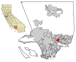
El Monte, California
| City of El Monte | |||
|---|---|---|---|
| — City — | |||
|
|||
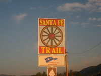
| Motto: End of the Santa Fe Trail | |||
 |
|||
| Coordinates: | |||
| Country | |||
| State | |||
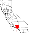
| County | Los Angeles | ||
| Incorporated | November 18, 1912 | ||
| Government | |||
| - Type | Council-Manager | ||
| - Mayor | Andre Quintero | ||
| - City Treasurer | Henry Velasco[1] | ||
| Area | |||
| - Total | 9.7 sq mi (25.1 km2) | ||
| - Land | 9.6 sq mi (24.7 km2) | ||
| - Water | 0.1 sq mi (0.4 km2) | ||
| Elevation | 299 ft (91 m) | ||
| Population (2000) | |||
| - Total | 115,965 | ||
| - Density | 12,142.9/sq mi (4,688.4/km2) | ||
| Time zone | PST (UTC-8) | ||
| - Summer (DST) | PDT (UTC−7) | ||
| ZIP codes | 91731-91735 | ||
| Area code(s) | 626 | ||
| FIPS code | 06-22230 | ||
| GNIS feature ID | 1652702 | ||

El Monte (pronounced /ɛl ˈmɒntiː/) is a residential, industrial, and commercial city [2] in Los Angeles County, California, United States. The city's slogan is "Welcome to Friendly El Monte," and historically is known as "The End of the Santa Fe Trail." As of the 2000 census, the city had a total population of 115,965. As of 2002, El Monte is the 191st largest city in the United States, and is the 44th largest city in California. El Monte Lies in the San Gabriel Valley region East of the city of Los Angeles.
Contents |
Origin of name
Between the 1770s and 1830s, missionaries and Spanish soldiers stopped here, and named the area, 'El Monte,' which referred not to a non-existent mountain, as most assume, but to an archaic Spanish definition of that era: 'meadow or marsh' or 'the wooded place. It was in the 1770s that a group of Missionaries and Spanish soldiers first explored this area and found an island of rich, low-lying land, covered with dense growths of wispy willows, alders, and cattails, located between two rivers,. The "Island", approximately 7 miles long and 4 miles wide, constituted a genuine oasis unrivaled in the midst of what naturally is a harsh, semi-arid environment.[3] In the 1850s, when the State Legislature organized California into smaller defined governmental units called townships, they named this area El Monte Township. Shortly afterward, the name reverted to the original: El Monte.[4]
History
Settlement began in 1849, though missionaries and Spanish soldiers passed through the area as early as the 1770s. The Old Spanish Trail, originating in Kansas City, Missouri in 1821, became the well-known Santa Fe Trail, the nation’s first major international commercial highway, stretching from Missouri to its official end in El Monte.[5] In the 1850s the village (renamed Lexington by American settlers) was the crossroad between Los Angeles, San Bernardino and San Pedro. It had a reputation as a rough town where men often settled disputes with knives and guns in its gambling saloons. Defense against Indian raids and the crimes of bandit gangs like that of Juan Flores and Pancho Daniel led to the formation of a local militia company called the Monte Rangers on February 23, 1854.[6] After the Monte Rangers disbanded, local justice in the form of a lynching was often provided by the local vigilantes called the "El Monte Boys".
The first permanent residents arrived in El Monte around 1849-1850, during a time when thousands migrated to California in search of gold. Though few found any gold, the migrants ventured upon the bounty of fruitful, rich land and began to build homesteads there. The farmers were very pleased at the increasing success of El Monte’s agricultural community, and it steadily grew over the years.[5] By 1861 El Monte had become a sizeable settlement and during the American Civil War was considered a hotbed of secessionist sympathies. A. J. King an Undersheriff of Los Angeles County (and former member of the earlier "Monte Rangers") with other influential men in El Monte, formed a secessionist militia company, like the Los Angeles Mounted Rifles, called the Monte Mounted Rifles on March 23, 1861. However the attempt failed when following the battle of Fort Sumter, A. J. King marched through the streets with a portrait of the Confederate General P. G. T. Beauregard and was arrested by a U.S. Marshal. State arms sent from Governor John G. Downey for the unit were held up by Union officers at the port of San Pedro. Union troops established New Camp Carleton near the town in 1862 to prevent any insurrection. It was closed in 1865.[7] The community of El Monte was the first in California founded by Americans of European descent. Once home to many settlers from the 1930s era Dust Bowl Migration, the city has become increasingly Hispanic and is often viewed as a stronghold of Latinos.
In 1866, the State Legislature, named the locality the El Monte Township and the village of Lexington was designated as its seat. In 1868, the village of Lexington returned to the name of El Monte. A Southern Pacific railroad depot was established there in 1873, spurring the development of local agriculture.[8][9] By 1912, El Monte was incorporated as a municipality.
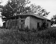
During the 1930s, the city became an important site for the New Deal's federal Subsistence Homestead project, a Resettlement Administration program that helped supply single-family ranch houses to qualifying applicants. Celebrated photographer Dorothea Lange snapped several pictures of the housing units as part of her work for the Farm Security Administration.
Representing the historical importance of the Santa Fe Trail, the city built the Santa Fe Trail Historical Park in 1989, at Valley Blvd and Santa Anita Ave.[5] The trail remained America’s greatest route for several decades thereafter.[10] The El Monte Historical Museum [11] at 3150 Tyler Avenue, is considered to be one of the best community museums in the state of California. El Monte is proud of their pioneer past and it lives on in their museum.[12]
Entertainment history
El Monte is credited with being the birth place of TV variety shows. Hometown Jamboree, a KTLA-TV Los Angeles-based show, was actually produced at the American Legion Stadium in El Monte, California in the 1950s.[13] The Saturday night stage show was hosted and produced by Cliffie Stone, who helped popularize country music in California.[14]
In the 1950s, as the unstable racial climate and the hostility toward rock & roll started to merge, rock & roll shows were forced from the City of Los Angeles by police pressure. The El Monte Legion Stadium, outside the city limits, became the site of a series for rock and roll concerts by Johnny Otis and other performers.[15] (Johnny Otis along with Alan Freed and Dick Clark were the major powers in the growing rock and roll industry.) During the fifties, teenagers from all over Southern California flocked to El Monte Legion Stadium every Friday and Saturday night to see their favorite performers. Famous singers who performed there include: the Ritchie Valens, Rosie & The Originals, Brenton Wood, Earth Wind & Fire, The Grateful Dead [16], Dick Dale and his Del-Tones and Johnny "Guitar" Watson. Disc jockeys Art Laboe and Huggy Boy enhanced the stadium's popularity with their highly publicized Friday Night Dances with many popular record artists of the late 1950s and 1960s. "El Monte Legion Stadium", as it was often called, was the "Happening" place to be for the teenagers of that era.[17] In a closed-circuit telecast, The Beatles and the Beach Boys were seen there on March 14, 1964.[18]
El Monte is known for the long-time rock & roll hit "Memories of El Monte", [1] written by Frank Zappa and originally recorded by The Penguins, one of the local Doo-wop groups from the 1950s that became famous nationwide. The song is in remembrance of The El Monte Legion Stadium and can be heard on many albums including Art Laboe's Memories of El Monte. Although the stadium closed their doors nearly 50 years ago, the music continues to live on.[19] El Monte was the birthplace of singer–guitarist Mary Ford, of Les Paul & Mary Ford fame. John Larkin, known as (Scatman John), is also a native. El Monte was home to musicians Gregg Myers and Joe McDonald, who performed in the 1960s with Country Joe & the Fish. Cheech Marin of Cheech and Chong fame was an El Monte denizen.
-
-
-
-
-
-
-
-
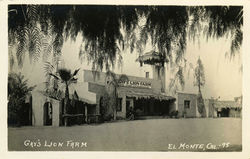 Gay's Lion Farm
-
-
-
-
-
-
-
A popular attraction from 1925 to 1942 was Gay's Lion Farm. Two European retired circus stars, Mr. and Mrs. Charles Gay, operated this tourist attraction, which has been called “the Disneyland of the 1920s and 1930s” by historian Jack Barton, [20] and many others of that era.. The Gays raised wild animals for use in the motion picture industry and housed over 200 African lions. Many of the lions starred in films during the 1920s and 1930s, including the Tarzan films starring Elmo Lincoln and Johnny Weismuller. The Metro-Goldwyn-Mayer lion logo was made with "Slats" (1924–1927), and his lookalike successor "Jackie". In 1925, El Monte Union High School adopted “The Lions” name for its teams, and the Gays provided a lion mascot for big games. The famous live lion farm was closed temporarily due to wartime meat shortages. It never reopened, but a life-sized memorial statue can be seen next to I-10 on the SE corner of Valley Boulevard and Peck Road. The original lion statue, commissioned for the Farm, stands in front of nearby El Monte High School.
Horse racing's most famous jockey, Willie Shoemaker, was a resident and attended El Monte High School, until he dropped out to work in the nearby stables.[21] El Monte was also briefly the home to author James Ellroy until his mother Geneva was murdered there in 1958.[22] Former baseball player Fred Lynn was a resident of El Monte. Actor-filmmaker Timothy Carey filmed much of his underground feature The World's Greatest Sinner (1962) in El Monte. Modern authors Salvador Plascencia, 33, and Michael Jaime-Becerra, 36, both grew up in El Monte and each references El Monte in his novels.[23] Mr. Ed, the Palomino of the classic 60s television show, was foaled in 1949 in El Monte and named "Bamboo Harvester".[24] Artist collective "mindfunk" work live art studio is based in El Monte. Since 2000 "mindfunk" has been producing underground urban multimedia artwork. [2]
Geography
El Monte is located at (34.073276, -118.027491).[25] According to the United States Census Bureau, the city has a total area of 9.7 square miles (25.1 km²), of which, 9.6 square miles (24.7 km²) of it is land and 0.1 square miles (0.4 km²) of it (1.44%) is water.
Climate
El Monte has a Mediterranean climate (Köppen climate classification Csa).
| Climate data for El Monte | |||||||||||||
|---|---|---|---|---|---|---|---|---|---|---|---|---|---|
| Month | Jan | Feb | Mar | Apr | May | Jun | Jul | Aug | Sep | Oct | Nov | Dec | Year |
| Source: [26] | |||||||||||||
Demographics
| Historical populations | |||
|---|---|---|---|
| Census | Pop. | %± | |
| 1950 | 8,073 |
|
|
| 1960 | 13,163 | 63.0% | |
| 1970 | 69,837 | 430.6% | |
| 1980 | 79,494 | 13.8% | |
| 1990 | 106,209 | 33.6% | |
| 2000 | 115,965 | 9.2% | |
| source: [27] | |||
The population has increased by more than 40% since the 1970s, homes replacing the walnut groves the city was known for.[2] As of the census[28] of 2000, there were 115,965 people, 27,034 households, and 23,005 families residing in the city. The population density was 12,139.5 people per square mile (4,688.4/km²). There were 27,758 housing units at an average density of 2,905.8/sq mi (1,122.2/km²). The racial makeup of the city was 72.39% of the population were Hispanic or Latino of any race, 35.67% White, 0.77% Black or African American, 1.38% Native American, 18.51% Asian, 0.12% Pacific Islander, 39.27% from other races, and 4.29% from two or more races.
There were 27,034 households out of which 53.3% had children under the age of 18 living with them, 57.0% were married couples living together, 18.5% had a female householder with no husband present, and 14.9% were non-families. 10.9% of all households were made up of individuals and 4.9% had someone living alone who was 65 years of age or older. The average household size was 4.24 and the average family size was 4.43.
In the city the population were 34.1% under the age of 18, 12.1% from 18 to 24, 31.5% from 25 to 44, 15.4% from 45 to 64, and 6.9% who were 65 years of age or older. The median age was 27 years. For every 100 females there were 102.1 males. For every 100 females age 18 and over, there were 101.0 males.
The median income for a household in the city was $32,439, and the median income for a family was $32,402. Males had a median income of $21,789 versus $19,818 for females. The per capita income for the city was $10,316. About 22.5% of families and 26.1% of the population were below the poverty line, including 33.9% of those under age 18 and 13.3% of those age 65 or over.
Politics
In the state legislature El Monte is located in the 24th Senate District, represented by Democrat Gloria Romero, and in the 49th Assembly District, represented by Democrat Mike Eng. Federally, El Monte is located in California's 32nd congressional district, which has a Cook PVI of D +17[29] and is represented by Democrat Judy Chu.
City Government
- The El Monte City Council is compromised of five members:
- El Monte City Mayor Andre Quintero
- El Monte Pro Tem Mayor Patricia Wallach
- El Monte City Councilman Juventino Gomez
- El Monte City Councilwoman Emily Ishigaki
- El Monte City Councilwoman Norma Macias
Following are the City Commissions in the City of El Monte, that advise the El Monte City Council:
- El Monte City Planning Commission
- El Monte City Veteran and Homeless Affairs Commission
- El Monte City Community Services Commission
- El Monte City Youth Commission
- El Monte City Patriotic Commission
- El Monte City Cultural Commission
- El Monte City Personnel Appeals Commission
- El Monte City Public Cable Access Commission
- El Monte City Permit Commission
- El Monte City Arts in Public Places Advisory Commission
- El Monte City Beautification Commission
Education
The El Monte Union High School District consists of the following schools:
- Arroyo High School
- El Monte High School
- Mountain View High School
- South El Monte High School
- Fernando R. Ledesma High School, Formerly known as Valley Lindo Continuation
- Rosemead High School
- El Monte-Rosemead Adult School
The El Monte City School District: The El Monte City School District is in El Monte, California. It includes 18 elementary schools: one serving grades K-4, one serving grades K-5, ten serving grades K-6, and six serving grades K-8. The district also administers four Head Start (preschool) sites, which are located at the elementary schools.
- Byron E. Thompson Elementary School,[3]
- Cherrylee Elementary School,[4]
- Cortada Elementary School, [5]
- Durfee Elementary School, [6]
- Cleminson Elementary School, [7]
- Legore Elementary School, [8]
Mulhall Elementary School
New Lexington Elementary School
Norwood Elementary School
Potrero Elementary School
Rio Vista Elementary School
Shirpser Elementary School
Thompson Elementary
Wilkerson Elementary School
Wright Elementary School
Cleminson Elementary School [9] Temple City
Rio Hondo Elementary School Arcadia
- Mountain View School District [10]
The Mountain View School District, located in the heart of the San Gabriel Valley, is a K-8 school district comprised of ten elementary schools, one intermediate school, one middle school, an alternative education program for students in grades 5-8, and a Children’s Center and Head Start/ State Preschool program. The District, with an enrollment of 8,600 students, serves the educational needs of students living in the cities of El Monte and South El Monte.
Baker Elementary School
Cogswell Elementary School
Kranz Intermediate School
La Primaria Elementary School
Madrid Middle School
Maxson Elementary School
Miramonte Elementary School
Monte Vista Elementary School
Parkview Elementary School
Payne Elementary School
Twin Lakes Elementary School
Voorhis Elementary School
Magnolia Learning Center
Children's Center/Head Start/State Preschool
Health Services
The Los Angeles County Department of Health Services operates the Monrovia Health Center in Monrovia, serving El Monte.[30]
Notable residents
- Lorenzo Oatman and his sister Olive Oatman, survivors of the Oatman Massacre of 1851 in Arizona
- Hilda Solis, served in the California State Assembly, the California State Senate, the United States House of Representatives, and serves as United States Secretary of Labor
- Scatman John was an American jazz musician and singer who created a fusion of scat singing and dance music
- Salvador Plascencia, author of The People of Paper
- Willie Shoemaker, Jockey
References
- ↑ California League of Cities, Elected City Treasurers
- ↑ 2.0 2.1 http://www.reference.com/browse/El+Monte
- ↑ http://home.earthlink.net/~jackbarton/ElMonteHistory.htm
- ↑ El Monte City Website Heritage page
- ↑ 5.0 5.1 5.2 http://www.villageprofile.com/california/elmonte/02/topic.html
- ↑ The California State Military Museum, California State Militia and National Guard Unit Histories: Monte Rangers
- ↑ The California State Military Museum, Historic California Posts: Camp Carleton (Camp Banning, Camp Prentiss, New Camp Carleton)
- ↑ http://www.britannica.com/EBchecked/topic/1076729/Gays-Lion-Farm
- ↑ http://www.britannica.co.jp/azbrowse/g/g24.html
- ↑ http://ohp.parks.ca.gov/default.asp?page_id=21427
- ↑ http://findlocal.latimes.com/el-monte/art/museum/el-monte-museum-of-history-el-monte-museum
- ↑ home.earthlink.net/~jackbarton/ElMonteHistory.htm
- ↑ http://www.countrymusichalloffame.org/full-list-of-inductees/view/cliffie-stone
- ↑ http://www.latimes.com/news/obituaries/la-me-molly-bee11-2009feb11,0,7175717.story
- ↑ http://www.musicianguide.com/biographies/1608000814/Johnny-Otis.html
- ↑ http://www.archive.org/details/gd1970-12-26.sbd.ashley-field.34031.sbeok.flac16
- ↑ http://www.free-press-release.com/news/200805/1211504190.html
- ↑ http://www.topix.net/album/detail/el-monte-ca/A8S40HCDILPQ4HIQ
- ↑ Even though the stadium closed their doors almost fifty years ago, the music and the memories, continues to live on.
- ↑ http://home.earthlink.net/~jackbarton/ElMonteHistory.htm
- ↑ http://www.yourdictionary.com/biography/willie-shoemaker
- ↑ http://www.ocregister.com/entertainment/ellroy-143160-says-movie.html
- ↑ http://www.chicagotribune.com/topic/la-ca-el-monte-20100425,0,4721719.story
- ↑ http://www.angelfire.com/film/horsefame/MrEd2.html
- ↑ "US Gazetteer files: 2000 and 1990". United States Census Bureau. 2005-05-03. http://www.census.gov/geo/www/gazetteer/gazette.html. Retrieved 2008-01-31.
- ↑ "Average weather for El Monte". Weather.com. http://www.weather.com/outlook/health/achesandpains/climatology/monthly/USCA0338?from=36hr_newslinker2. Retrieved 2009-03-29.
- ↑ "CENSUS OF POPULATION AND HOUSING (1790-2000)". U.S. Census Bureau. http://www.census.gov/prod/www/abs/decennial/index.html. Retrieved 2010-07-18.
- ↑ "American FactFinder". United States Census Bureau. http://factfinder.census.gov. Retrieved 2008-01-31.
- ↑ "Will Gerrymandered Districts Stem the Wave of Voter Unrest?". Campaign Legal Center Blog. http://www.clcblog.org/blog_item-85.html. Retrieved 2008-02-10.
- ↑ "Monrovia Health Center." Los Angeles County Department of Health Services. Retrieved on March 27, 2010.
External links
|
||||||||||||||||||||
|
|||||||||||||||||||||||||||
|
|||||||||||||||||